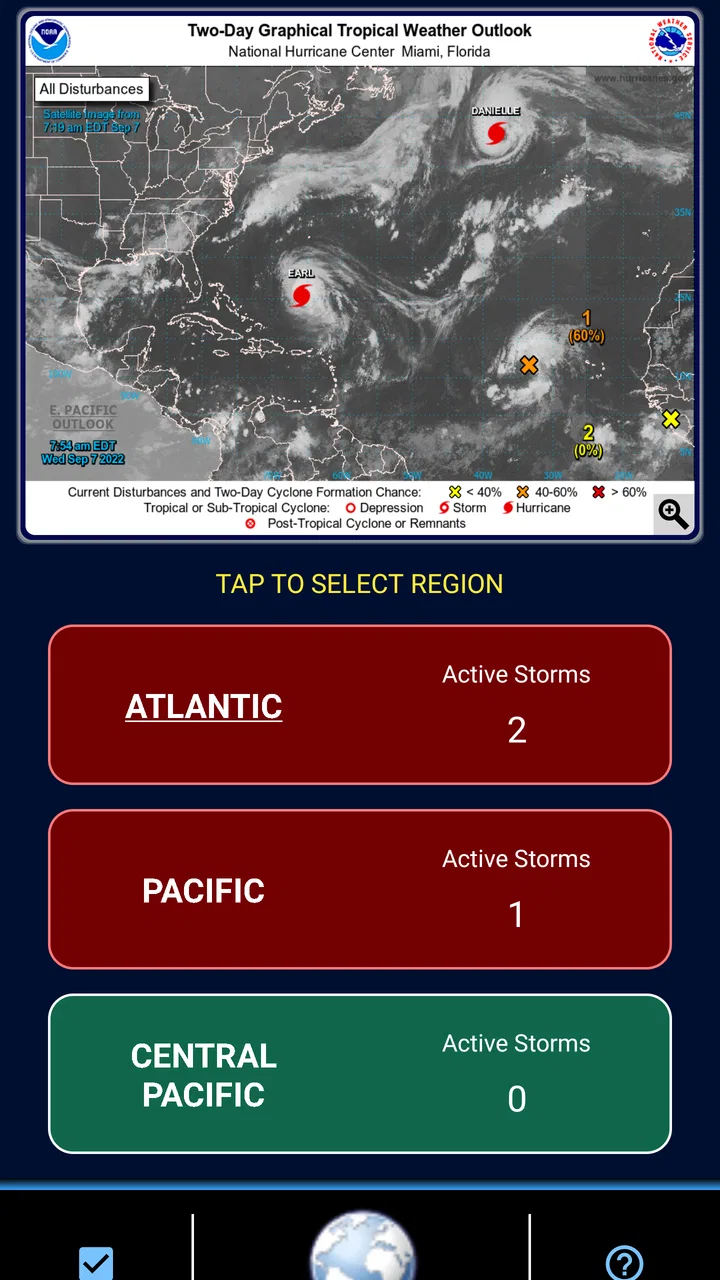
Track-It Hurricane Tracker
- 4.6
- Rating
- 50.00K
- Installs
- Free
- Price

 Analysis by App-foxy
When a hurricane is approaching, I do not want a weather app that makes me dig through decorative screens before showing the information that matters. Track-It Hurricane Tracker takes a more direct approach. Developed by Down South Customs, this free weather app is built around following tropical systems and keeping the essential details close at hand. I found that focus useful, especially when checking conditions quickly rather than casually browsing a full weather service.
The app is listed for Everyone, runs on Android 5.0 and later, and its current version is 7.1.05. It has been available since September 23, 2010, which gives it a much longer history than many narrowly focused weather tools. With more than fifty thousand installs and a 4.6 average from over five hundred ratings, it has clearly found an audience among people who want a dedicated hurricane-tracking option rather than a general forecast app.
How Track-It handles readability and navigation
My first impression was that the app’s purpose is easy to understand. It is not trying to be a complete replacement for every weather service on a phone. The central task is tracking hurricanes, so the interface feels more purposeful than a typical forecast app filled with hourly temperatures, lifestyle panels, radar layers, and unrelated alerts.
You May Also Like

 Blood Strike: 2.5 Anniversary
Blood Strike’s Loadouts Turn Every Drop Into a Tactical Gamble
A close look at Blood Strike’s custom loadouts: how fast access to signature weapons reshapes its battle royale rhythm, rewards preparation, and narrows the gap between fights.

 Pandora - Music & Podcasts
Pandora’s Music Is Easy to Start, but Harder to Recover
Pandora’s strength is its low-effort path from a seed to a station. Its weak spot is how much confidence it asks you to place in connection, setup, and quiet recovery.

 8 Ball Pool
 Is Built on Rivalries, Rematches, and Routine
A close look at the rivalries, rematches, shared routines, and unanswered safety questions that turn a quick pool match into a persistent mobile community.

 Samsung Music
’s Quiet Strength Is Playing What You Already Own
Its reach comes less from spectacle than from dependable access to a personal library. That simplicity is both the app’s strongest retention engine and its ceiling.

 AccuWeather: Weather Radar
AccuWeather Review: A Quick, Clear Forecast for Everyday Decisions
For everyday plans, the best forecast is the one you can understand quickly. AccuWeather makes rain timing, radar, and local conditions easy to act on, with a few trade-offs.

 Hill Climb Racing
Why Hill Climb Racing Still Turns Crashes Into One More Run
A tiny car, a bumpy hill and one more upgrade: Hill Climb Racing keeps resurfacing because its simple chaos makes every near-miss feel personal.
More From Our News Desk
View All News


That narrow focus can be helpful for readers who become overwhelmed by crowded weather dashboards. Instead of deciding which part of a broad forecast is relevant, you can approach the app with a clear question: what is happening with a tropical system, and what should I watch next? That makes the experience easier to explain to a family member who is not comfortable with complicated weather terminology or layered map controls.
Text-based information is particularly valuable during a stressful event. A map can show a broad picture, but written details help me slow down and confirm what I am looking at. I recommend reading the available storm information before relying on the visual path alone. A projected line is not a promise about where dangerous weather will occur, and the difference between the center of a storm and its wider effects matters in real life.
The app’s long-standing design also means it may feel more functional than fashionable. People who expect the polished motion, large cards, and highly animated layouts found in newer mainstream weather apps may find Track-It less immediately attractive. I see that as a trade-off rather than an automatic flaw: a simpler presentation can reduce distractions, but older-looking controls may take a little longer to understand.
Why a focused screen can help under pressure
During a storm, I would rather open a specialized tracker before scrolling through a general weather feed. That is one of the app’s strongest practical ideas. A general service is excellent for deciding whether to carry an umbrella or plan a commute, while Track-It is more appropriate when tropical activity becomes the reason I am checking the forecast at all.
A useful habit is to check the tracker at calm times, before an emergency develops. I would open it, identify where the main information appears, and make sure I understand the navigation while conditions are still normal. This is a small step, but it reduces the chance of trying to learn an unfamiliar interface during a power outage, rushed evacuation preparation, or a noisy family discussion.
The app is also easier to use when paired with another source rather than treated as the only authority. I use a dedicated tracker for orientation, then compare important decisions with official local emergency guidance and current alerts. That workflow gives Track-It a clear role: it helps me follow the storm, while local authorities provide instructions about roads, shelters, evacuation zones, and immediate safety.
Motor and sensory considerations in everyday use
For users with limited dexterity, the most important question is whether the app can be operated without precise, rapid gestures. Track-It benefits from being a focused utility rather than a game-like experience. I do not approach it expecting constant swiping or fast reactions. Still, map-based weather tools naturally require some touch interaction, and that can be tiring for anyone who has tremors, reduced hand strength, or difficulty with small controls.
My practical advice is to use the app in a stable position, with the phone supported on a table or held by a case that provides grip. That sounds simple, but it makes a noticeable difference when a user needs to inspect a map carefully. I would also avoid trying to interpret a storm while walking, driving, or carrying supplies. The best accessibility improvement in that situation is not a setting inside the app; it is choosing a safer moment and a steadier surface.
For people with low vision, map interpretation may be the main challenge. A storm track can contain lines, markers, labels, and geographic shapes that become difficult to distinguish when the display is small or the lighting is poor. I found that zooming in deliberately and checking one area at a time is more reliable than trying to understand the whole map in a single glance. If a written storm detail is available, I would use it to confirm what the map appears to show.
Users with color-vision differences should be cautious with any weather visualization that depends on color alone. I would not assume that a colored line or marker communicates its meaning without a label or accompanying text. When the information is important, I look for the written explanation and compare it with the map rather than relying only on visual contrast.
For sensory-sensitive users, a dedicated hurricane tool may be less exhausting than a news-heavy weather app because there is less unrelated content competing for attention. On the other hand, storm tracking itself can be emotionally intense. Repeatedly refreshing a map can increase anxiety without adding useful knowledge. I get better results by checking at sensible intervals, recording the relevant update, and then returning to practical preparation instead of watching the screen continuously.
Using it when the usual phone setup is not available
Situational access is just as important as permanent disability access. A person may have full dexterity and vision but still struggle when the phone is in bright sunlight, the network is busy, the battery is low, or the user is wearing gloves. Track-It is most useful when I prepare before those conditions appear. I keep the phone charged, avoid depending on a single information source, and learn the basic route through the app ahead of time.
Bright outdoor conditions can make maps and small text harder to read. I prefer checking indoors or in shade when possible, increasing the phone’s display brightness only when necessary, and turning the device so reflections are reduced. If I am outside during preparation, I would not let the app distract me from surroundings, traffic, or instructions from emergency personnel.
Gloves create another small but realistic barrier. A user preparing a property may have difficulty with delicate touch controls, particularly when repeatedly zooming or selecting map elements. I would check the app before putting on work gloves, note the information that matters, and use a larger, simpler interaction whenever possible. This is one reason I consider the app more valuable for monitoring and planning than for frantic use in the middle of an outdoor task.
People who share a phone with relatives can also benefit from its focused purpose. One person can open the tracker, explain the storm position, and then hand the phone to someone else without navigating through a large collection of unrelated widgets. For older adults, caregivers, or family members who speak about weather in different ways, that simplicity can support a short conversation: identify the system, discuss the likely local relevance, and then move to official instructions.
At the same time, I would not use it as a substitute for emergency communication. A tracker can help me understand a developing situation, but it does not replace evacuation notices, shelter information, emergency calls, or direct guidance from local agencies. That distinction is especially important for users who may have limited mobility and need more preparation time. The app can support awareness, but the action plan must be built around the person’s actual needs, transportation, medication, support network, and location.
What advanced users can do with it
The most useful non-obvious workflow is to separate monitoring from decision-making. I use the app to observe the storm’s development, but I do not convert every small change on the screen into a new personal plan. Instead, I identify meaningful triggers in advance: a local warning, an official evacuation instruction, or a change that affects my route or household arrangements. This prevents the tracker from becoming a source of constant second-guessing.
Another helpful approach is to compare the app’s broad storm picture with local geography. A projected center line should not be read as a narrow safe-or-dangerous boundary. I look at where I live, where family members live, and which roads or low-lying areas connect us. This makes the app more useful for coordination, particularly when several people need to decide whether to stay together or move early.
I also recommend using it as a teaching tool before hurricane season. I can show a less experienced user how a tropical system is represented, explain why the center path is only part of the story, and practice finding the information without the pressure of an active emergency. For someone with cognitive or learning difficulties, repetition in a calm setting is often more effective than a long explanation delivered during a warning.
These workflows reveal the app’s real strength: it gives a dedicated place to follow hurricane activity. Its value is not that it eliminates uncertainty. No tracker can do that. Its value is that it helps organize attention, provided I combine it with sound judgment and authoritative local information.
Remaining barriers and trade-offs
The biggest limitation is scope. Someone looking for pollen levels, air quality, minute-by-minute rain predictions, a full radar suite, or a detailed daily forecast may prefer a broader weather application. Track-It makes more sense when hurricanes are the central concern. Installing it for ordinary weekly weather would be excessive unless that specialized focus is something I genuinely need.
There is also a learning curve for anyone unfamiliar with tropical weather maps. Labels, projected paths, and storm terminology can be confusing without context. The app can present useful tracking information, but it cannot teach every user how to interpret risk for a particular building, neighborhood, or coastline. I would spend time learning the basics from trusted weather and emergency sources rather than assuming the display explains everything by itself.
The free price makes trying it easy, although optional in-app purchases range from ninety-nine cents to four dollars and ninety-nine cents per item. I would review any purchase screen carefully and decide whether an extra function genuinely improves my workflow. The core reason to install the app is focused hurricane tracking, so I would not pay simply because a storm is making me anxious or because a more elaborate display looks impressive.
Its age is another consideration. Support for Android 5.0 makes it available to older devices, which can be useful for households that keep an older phone as a backup. However, people using very old hardware may encounter slower map handling or a less comfortable display than they would on a newer device. I would test it before relying on that phone during an emergency, especially if the device is already showing battery or performance problems.
Users who need large, high-contrast controls, spoken guidance, or extensive screen-reader optimization should evaluate the app personally before making it their main tool. I found the focused purpose encouraging, but specialized purpose is not the same thing as comprehensive accessibility. If a person cannot comfortably read the map or operate the controls, a different weather service with stronger device-assistance compatibility may be the better choice.
Likewise, anyone who needs guaranteed offline access should plan carefully. A tracker is only helpful when the phone can obtain current information, and storm preparation can involve outages or overloaded networks. I would download or note essential local contacts, keep battery-saving plans ready, and avoid assuming that an app alone will remain sufficient throughout a crisis.
Who should install it
I think Track-It Hurricane Tracker is a good fit for coastal households, travelers who regularly visit hurricane-prone areas, family coordinators, and anyone who wants a dedicated tropical-weather screen beside a general forecast app. It is especially useful for people who prefer a focused tool and are willing to spend a few minutes learning how to read the information before conditions become urgent.
It is less suitable for someone who wants one polished app to handle every weather question. If your daily needs are mostly temperature, rain timing, radar, and commute planning, a mainstream weather service will probably feel more complete. I would also steer users with significant visual, motor, or cognitive barriers toward a trial run with a trusted helper before relying on it. A tool that is theoretically relevant but physically difficult to operate is not a practical safety tool.
The app’s Everyone age rating makes it appropriate for a household setting, but younger users should still be guided by an adult when interpreting storm risk. A child can learn where to look and help monitor updates, yet evacuation and shelter decisions belong with responsible adults and official instructions.
My inclusive verdict
After using it as a focused hurricane companion, I see Track-It Hurricane Tracker as a practical specialist rather than a complete weather replacement. Down South Customs has kept the app centered on a clear need, and that focus can make storm information easier to approach than a crowded all-purpose forecast. Its strongest accessibility quality is contextual: when I already know why I am opening it, there is less irrelevant material competing for attention.
The experience is not barrier-free. Map reading can challenge people with low vision or color-vision differences, touch interaction may be awkward for users with limited dexterity, and stressful or low-connectivity situations require preparation beyond the app itself. Those are not reasons to dismiss it, but they are reasons to test it with the actual person, phone, lighting, gloves, and support arrangements that will matter in practice.
With a 4.6 average across more than five hundred ratings, it has earned a positive reception, and I understand why. The free entry point, long availability, and specialized purpose make it easy to add to a hurricane-preparation routine. I would use it alongside official alerts and local emergency guidance, not instead of them.
My recommendation is simple: install it if you want a dedicated way to follow hurricanes, then practice using it before you need it. For me, that combination of focused tracking and advance preparation is what makes the app worthwhile. It will not remove uncertainty or solve every accessibility need, but it can give a household a clearer starting point when tropical weather becomes the main thing that matters.
In the end, Track-It Hurricane Tracker works best as one part of an inclusive safety routine. Pair it with readable local instructions, a charged phone, a backup communication plan, and support for anyone who cannot easily interpret or operate the display. Used that way, it is a sensible free weather app for hurricane awareness, with enough focus to earn a place beside—not necessarily in place of—the usual alternatives.
FAQs for Track-It Hurricane Tracker
01What is Track-It Hurricane Tracker used for?
Track-It Hurricane Tracker is designed to help users monitor tropical storms, hurricanes, and other significant weather systems. It typically presents storm locations, projected paths, intensity information, warnings, and related weather data in an accessible format. It can be useful for residents, travelers, boaters, and anyone following an active storm, although it should be used alongside official emergency and weather-service information.
02Does Track-It Hurricane Tracker provide real-time hurricane information?
The app is intended to display frequently updated storm information, but the exact update timing can depend on the data source, internet connection, and the availability of official advisories. Users should not assume that every map change is instantaneous. During a developing emergency, always compare the app’s information with official alerts from national weather agencies, local authorities, and emergency-management services before making safety decisions.
03Can I use the app without an internet connection?
Track-It Hurricane Tracker generally requires an internet connection to retrieve current storm positions, forecasts, satellite imagery, warnings, and other changing weather data. Some previously loaded information may remain visible temporarily, but offline availability should not be treated as guaranteed. If you may lose connectivity during a storm, save important emergency contacts, evacuation details, and official instructions before conditions deteriorate.
04Does Track-It Hurricane Tracker send storm or emergency notifications?
Depending on the version and your device settings, Track-It Hurricane Tracker may offer notifications or alerts related to tropical systems, forecast updates, or nearby threats. Notification behavior can vary by region, subscription level, operating-system permissions, and the data provider. After installation, review the app’s alert settings and allow notifications if desired, while remembering that local government emergency alerts remain essential.
05Is Track-It Hurricane Tracker accurate enough for evacuation or safety decisions?
The app can be a convenient tool for visualizing storm development and following forecasts, but no tracking application can predict a hurricane’s exact path, timing, or local impact with complete certainty. Wind, rainfall, flooding, storm surge, and tornado risks may extend well beyond the displayed center or cone. Use the app for awareness, then follow official evacuation orders and emergency guidance immediately.
Pros
- Clear storm paths help users understand a hurricane’s projected movement.
- Useful tracking maps make it easy to monitor multiple storms at once.
- Weather updates can support travel and emergency-preparedness decisions.
- Focused hurricane information is less cluttered than a general weather app.
- Helpful for users living in or near areas affected by tropical systems.
Cons
- Forecast paths can change quickly and should not replace official warnings.
- Some advanced tracking details may require a paid subscription or upgrades.
- Storm information may be limited outside the Atlantic and other supported regions.
- Frequent alerts can become overwhelming during an active hurricane season.
- The app’s usefulness is seasonal when no tropical systems are developing.

Track-It Hurricane Tracker
Gallery